Bridges and locks in places starting with a 'K'

Click on the name of the Lock or Bridghe to request more information. You can sort the list by clicking on the words 'Bridge/lock' and 'Place' above the table.

Bridge/lock (click on the name)  Place  Website  Show
Kakeshoek, brugKakeshoekWater map
Kalenberg, brugKalenbergWater map
Eilandbrug, KampenKampenWater map
GanzensluisKampenWater map
Stadsbrug, KampenKampenWater map
ScheeresluisKamperveenWater map
PostbrugKapelleWater map
HongersdijckbrugKatsWater map
brug over buitenhoofd ZandkreeksluisKatsWater map
ZandkreeksluisKatsWater map
SandtlaanbrugKatwijk a/d rijnWater map
Nieuwe RoversbrugKatwijk aan den rijnWater map
RietvinkbrugKatwoudeWater map
ErpsebrugKeldonkWater map
KampersluisKetelhavenWater map
KetelsluisKetelhavenWater map
Kampersluis, brug over benedenhoofdKetelhavenWater map
Ketelsluis, brug over benedenhoofdKetelhavenWater map
HalfstuuverbrugKiel-windeweerWater map
Kiesterzijl, brugKiesterzijlWater map
OranjesluisKlazienaveenWater map
Klein Groningen, brugKlein groningenWater map
Klein Groningen, voetbrugKlein groningenWater map
UlsterbrugKlein ulsdaWater map
Kleine Sluis, brugKleine sluisWater map
Assen, KloosterbrugKloosterveenWater map
BraaksluisKolhornWater map
MolenkolksluisKolhornWater map
Kollumer Nieuwe Zijl / Kollumer Nieuwe Zijl, ZijlsterrijdKollumWater map
ZijlsterrijdbrugKollumeroudzijlWater map
CoenbrugKoog aan de zaanWater map
MallegatsluisKoog aan de zaanWater map
Prins Willem Alexanderbrug, Koog aan de ZaanKoog aan de zaanWater map
Brug KootstertilleKootstertilleWater map
brug in de A7 KornwerderzandKornwerderzandWater map
LorentzsluizenKornwerderzandWater map
brug in de A7(b) KornwerderzandKornwerderzandWater map
RaaisluisKortenhoefWater map
Raaisluis, brug over binnenhoofdKortenhoefWater map
KoudekerksebrugKoudekerk aan de rijnWater map
De KuinreKoudumWater map
Voorstersluis, brug over benedenhoofd (in N352)KraggenburgWater map
VoorstersluisKraggenburgWater map
KadoelerbrugKraggenburgWater map
Wetsingersluis, fietsbrug overKrassumWater map
Algerabrug (deel over de sluis)Krimpen aan den ijsselWater map
Krommenie, brug (in N203, O-W)KrommenieWater map
spoorbrug KrommenieKrommenieWater map
Krommenie, brug (in N203 W-O)KrommenieWater map
Vaartbrug, KrommenieKrommenieWater map
LeinebrugKropswoldeWater map
brug over benedenhoofd sluis KuinreKuinreWater map
sluis KuinreKuinreWater map
Kuzemerbalk, fiets/voetbrugKuzemerbalkWater map


Bridges & Locks alphabet

Choose the first letter of the city or village in which you want to see the bridges:

A  B  C  D  E  F  G  H  I  J  K  L  M
N  O  P  Q  R  S  T  U  V  W  X  Y  Z


Bridges by province

Drenthe
Flevoland
Friesland
Gelderland
Groningen
Limburg
Noord-Brabant
Noord-Holland
Overijssel
Utrecht
Zeeland
Zuid-Holland


Download the app

Always have the current bridge and lock times at hand? With the Water Map Live app you stay informed.

Screenshot app Water Map Live

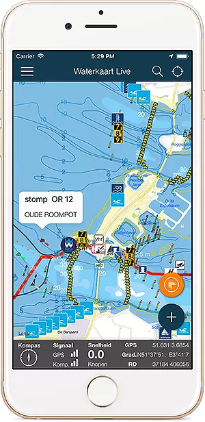
Download the app for iOS or Android.

Download Water Map Live, app for Android  Download Water Map Live for iPhone and iPad

About Water Map Live

Water Map Live is the water website and app of the Netherlands. Here you will find the most important information that you need as a nautical professional, water sports enthusiast, swimmer, water lover or weather enthusiast. Fast and complete.

Do you have good ideas or suggestions, do you want to collaborate or reuse data? Let us know, we'd love to hear from you!
 
Water Map Live for free in your website

Want to know more about Water Map Live?
Surfcheck / Waterkaart Live
Rijn en Schiekade 115 F
2311 AS Leiden (NL)
(+31) 071-2032041
Kvk: 61380431

post@waterkaart.net
 
Frequently asked questions

Download Water Map Live
 
Download Water Map Live, the app for Android   Download Water Map Live, the app for iPhone and iPad