Weather forecasts

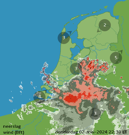
Wind forecast North Sea and inland

The wind forecast for the North Sea, the Netherlands, Belgium and Luxembourg. Maps per hour, for the next 40 hours in knots, Beaufort and air pressure. Be sure to check out the detailed maps of the Wadden, the IJsselmeer and the Frisian Lakes and for Zeeland.

North Sea Current Atlas + Weather influences

The hourly forecast of the currents in the North Sea, in knots and meters per second

UKMO Fax charts

MetOffice's well-known fax charts, analysis and forecasts for the coming days.

HiRLAM analysis and forecast

The HiRLAM analysis map and ECMWF forecast maps for the coming days, updated twice daily by the KNMI.

DWD ICON analysis and forecast

The German Weather Service provides beautiful analysis and forecast maps from its own ICON weather model every day, also for the Atlantic region.

ECMWF 850 hPa analysis Atlantic Ocean

The current ECMWF model output of the air pressure distribution at the 850 hectopascal level. Gives a good impression of the larger movements of high and low pressure areas and wind speeds.

The current satellite image

The most recent Meteosat 8 satellite image of Western Europe and the current satellite film.

Synoptic analysis KNMI

The Synoptic analysis and model assessment by the KNMI meteorologist on duty. Updated several times a day.

Weather plumes Netherlands

Weather plumes with 14-day forecasts for seven locations in the Netherlands, based on the GFS weather model.

Current weather reports Netherlands

The current weather and 24 hour forecast for more than 5000 places (click)
 

Weather warning

23/02/2025 01:57

There are no warnings

There are currently no warnings in force.


Live maritime observations


Weather report KNMI: First grey, from the south from the sun. Monday periods of rain.

The current KNMI weather report (automatically translated)

Prepared: 23/02/2025 04. 12 hours


Next night, it's going to rain from the west in more and more places. The minimum temperature is around 8°C. The wind comes from the south and is moderate, by the sea and on the IJsselmeer quite powerful to powerful, wind force 5 to 6. Short term: Variable and temperatures above the long-term average. From Wednesday dryer and to the east chance of light frost. Long-term average: 7. 9°C


KNMI radar with wind force


KNMI radar with lightning visualisation