Wirdumerpoortsbrug / Wirdumerpoortsbrug, Leeuwarden, in Leeuwarden: opening hours and contact

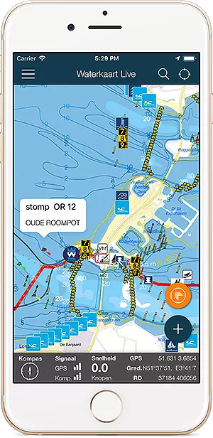
All about the Wirdumerpoortsbrug / Wirdumerpoortsbrug, Leeuwarden, location, opening hours and contact details. On the water map below do you see the bridge in its immediate vicinity. On the right on this page you will find the operating times of this bridge, if available the maritime radio data and telephone numbers, and any additional instructions.


Open the Water Map for Leeuwarden in full window


Opening hours of nearby bridges

1. Hempens: Oxena brids, draaibrug
2. Hempens: Hempensbrug / Hempens, Leeuwarden (photo)
3. Leeuwarden: Spoorbrug HRMK (photo)
4. Leeuwarden: Pylkwiersterbrege
5. Leeuwarden: 1e Kanaalsbrug
6. Leeuwarden: Vrouwenpoortsbrug (photo)
7. Leeuwarden: Noorderbrug, Leeuwarden (photo)
8. Leeuwarden: Slauerhoffbrug, Leeuwarden (photo)
9. Leeuwarden: Spoorbrug HRM (photo)
10. Leeuwarden: Van Harinxmabrug (photo)
11. Leeuwarden: Verlaatsbrug, Leeuwarden
12. Leeuwarden: Eebrug, Leeuwarden (photo)
13. Leeuwarden: Blokhuisbrug, Leeuwarden
14. Leeuwarden: Greunsbrug, Leeuwarden
15. Leeuwarden: 2e Kanaalsbrug
16. Leeuwarden: Greunsspoorbrug
17. Leeuwarden: Hermesbrug (photo)
18. Leeuwarden: Oosterbrug / Oosterbrug, Leeuwarden (photo)
19. Leeuwarden: Blokhuispoortbrug / Blokhuispoortbrug, Leeuwarden (photo)
20. Leeuwarden: 2e kanaalsbrug / 2e Kanaalsbrug, Leeuwarden (photo)
21. Leeuwarden: Greunsbrug / Greunsbrug, Leeuwarden (photo)
22. Leeuwarden: Eebrug / Eebrug, Leeuwarden (photo)
23. Leeuwarden: Verlaatsbrug / Verlaatsbrug, Leeuwarden (photo)
24. Leeuwarden: Hermesbrug / Hermesbrug, Leeuwarden (photo)
25. Leeuwarden: Harinxmabrug / van Harinxmabrug, Van Harinxmakanaal (photo)
26. Leeuwarden: Vlietsterbrug / Vlietsterbrug, Leeuwarden (photo)
27. Leeuwarden: Spoorbrug Greuns / Spoorbrug, Leeuwarden (photo)
28. Leeuwarden: Vlietsterbrug
29. Leeuwarden: Oosterbrug Leeuwarden
30. Warga: Grote brug te Warga
31. Wergea: Palmabrege (photo)
32. Wergea: Palmabrêge / Palmabrêge, Wergea/Grou e.o. (photo)
33. Wergea: Wergea 1e brug / Wergea 1e brug, Foudering (photo)
34. Wergea: Eerste brug in Wergea


More information

How does crossing a movable bridge work?

The Netherlands has more than 1500 movable bridges. What rules do you have to observe when passing, when do you have to wait, what do the lights mean and how do you ensure that the bridge keeper notices you?


Marinas nearby

1. Britsum: W.V. De Klompskippers
2. Deinum: Jachthaven Deinum (photo)
3. Leeuwarden: Jachthaven De Prinsentuin (photo)
4. Leeuwarden: Jachthaven De Grote Wielen
5. Leeuwarden: De Nieuwe Leeuwarder Jachthaven (photo)
6. Leeuwarden: Hemrik Marine (photo)
7. Leeuwarden: Jachthaven de Zwemmer
8. Leeuwarden: Watersport Twee Provinciën (photo)
9. Mantgum: Passantenhaven Mantgum
10. Weidum: Hotel/Restaurant Weidumerhout


Zo werkt de vaarrouteplanner

Als je de Waterkaart Live app gebruikt, kun je zelf vaarroutes plannen en opslaan. Daarbij houdt de route rekening met de hoogte van bruggen (en sluizen) op je route. Het gebruik van de routeplanner is eenvoudig, op deze pagina leggen we uit hoe het werkt. Deutsche Version …


Brug open? Gebruik de app en het gaat vanzelf

Goed nieuws voor wie door Noord-Holland vaart: vanaf nu kun je via Waterkaart Live automatisch brugopeningsverzoeken laten sturen. Zo wordt varen een stuk makkelijker en hoef je minder te wachten. Je hoeft alleen de Netwerk-AIS functie aan te schakelen. Zo werkt dat. …


Bridge times Wirdumerpoortsbrug-/-Wirdumerpoortsbrug,-Leeuwarden

Wirdumerpoortsbrug / Wirdumerpoortsbrug, Leeuwarden

From 2024-03-23 until 2024-04-30

Working days, from 09:00 - 10:00 *
14:00 - 15:00 *
Saturday, from 09:00 - 10:00 *
Sunday closed

* = bediening op aanvraag via 06-11809163 (bereikbaar ma t/m vrij 08:30-16:00 uur min 2 uur van te voren)

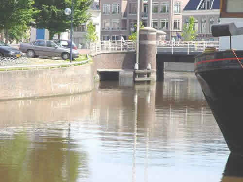
Foto: Provincie Fryslân
 

Vertical clearance when closed: 1.96 meter, width: 6.00 meter.

Note: vertical clearance compared to NAP, take local water levels into account. There is one target level for the Frisian reservoir - the connected system of canals and lakes in Friesland - which is 52 centimeters below NAP.

Data updated: 26 April 2024, 14:00 uur, delivered by the Province of Friesland.

Is something incorrect in the above information? Submit your changes via: provincie@fryslan.frl


Download the app

Always have the current bridge and lock times at hand? With the Water Map Live app you stay informed.

Screenshot app Water Map Live

Download the app for iOS or Android and try this for free.

About Water Map Live

Water Map Live is the water website and app of the Netherlands. Here you will find the most important information that you need as a nautical professional, water sports enthusiast, swimmer, water lover or weather enthusiast. Fast and complete.

Do you have good ideas or suggestions, do you want to collaborate or reuse data? Let us know, we'd love to hear from you!
 
Water Map Live for free in your website

Want to know more about Water Map Live?
Surfcheck / Waterkaart Live
Rijn en Schiekade 115 F
2311 AS Leiden (NL)
(+31) 071-2032041
Kvk: 61380431

post@waterkaart.net
 
Frequently asked questions

Download Water Map Live
 
Download Water Map Live, the app for Android   Download Water Map Live, the app for iPhone and iPad